The Antarctic Programme
The Antarctic is changing. Climate change, ocean acidification, changes in land and sea ice, and increasing human activity both on the continent and in the oceans outside, are contributing to these changes. Better knowledge of ongoing changes and the mechanisms that control these is necessary to be able to predict the changes that nature and society will face in the years ahead.
Through monitoring and research, the Antarctic Programme will produce data and knowledge as a basis for advice to the administration on the geology, climate, nature, ecosystems and environmental development in the Antarctic.
The geographically most important areas for the Antarctic Programme are Dronning Maud Land, Kong Håkon VII Hav, Bouvetøya and the sea areas around Bouvetøya, but also other areas in which the Norwegian administration has special interests.
Contact
Programme leader: Birgit Njaastad
Outreach contact: Stig Mathisen
Studying the mass balance of Fimbulisen. Photo: Elvar Ørn Kjartansson / Norwegian Polar Institute
Monitoring
TONe Multidisciplinary Ocean Moored Observatory (MOMO)
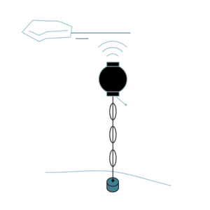
The physical ocean system is closely linked to the carbon cycle and the marine ecosystem. Together with international partners, the Norwegian Polar Institute (NP) will contribute to improving the understanding of processes and systems, so that we can see how the ecosystem adapts.
Through TONe, NP and UiB will further develop existing ocean rigs and oceanographic measurements over the continental shelf at 6°E by harmonizing instruments to national standards. We will also set up sound sources so that we can bring autonomous gliders for additional data collection under the ice. The rigs are maintained from the established TrollTransekttokt – whose goal is to use the annual supply ship to Troll as a platform for regular marine observations.
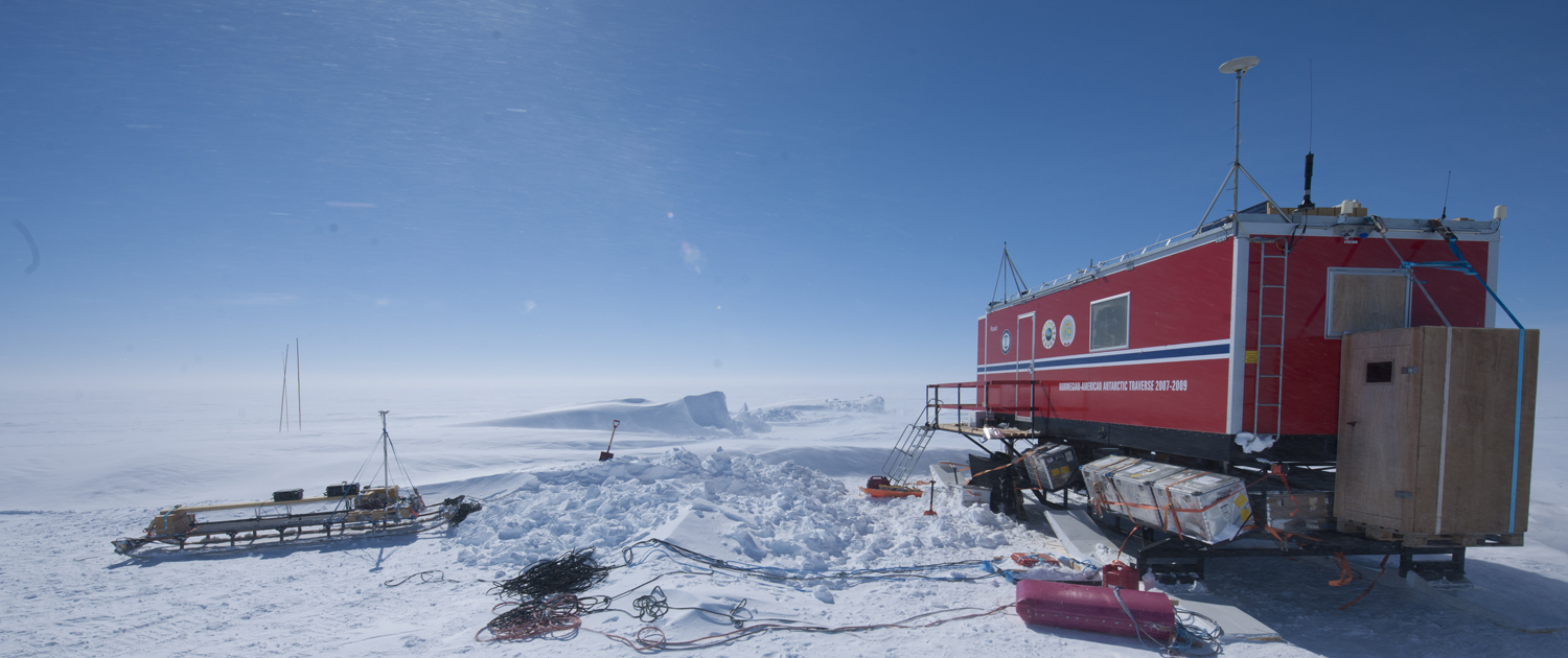
TONe Fimbulisen Ice Shelf Observatory (FIO)
One of the most serious consequences of global warming is sea level rise. Future sea level rise is influenced by the melting of the Antarctic ice sheet, but there is particularly great uncertainty associated with the melting of the ice shelf, the ocean’s influence on it, and the ice shelf’s response. We need to find answers to how stable the current cold regime in the area is, and what the potential drivers of change are.
Fimbul is the largest ice shelf in Queen Maud Land. During the International Polar Year in 2009, NP and partners drilled and established sites for measurements of mass balance and ocean properties on and below the ice shelf. The instrumentation was expected to last 5–10 years, but is still measuring. Through TONe, we will now drill again and replace the instrumentation in order to continue the time series – the longest for such measurements. This means a demanding 50-day remote field operation, 15 tons of research equipment and a tracked vehicle traverse of 2500 km at 12 km/h.
- Instrumentation at two locations; preliminary studies for a third location
- Continue and develop time series:
- Ice shelf mass balance
- Warm water inflow
- Turbulence measurements in the ice shelf-ocean boundary layer
- Instruments for future glider campaign under the ice
- In-situ measurements in boreholes during establishment
Fast-is-overvåking
More infomation will come.
Atmospheric radiation (Troll og Zeppelin)
Atmospheric radiation is continuously measured at the Zeppelin Observatory in Ny-Ålesund and at the Troll Research Station in Dronning Maud Land, Antarctica. Both sites have instruments mounted on a platform which moves with the sun, enabling us to measure the light that comes directly from the sun separately from what is dispersed by the atmosphere and originates from the rest of the sky. One instrument measures all incoming sunlight from all directions, while another measures infrared light radiated by the atmosphere. Using these measurements, we are able to monitor an important part of the climate system – the energy that is available to heat the surface of the Earth. We can also better understand the importance of processes in the atmosphere that affect sunlight and the radiation of infrared light (e.g. clouds).
Mass balance glaciers
Kongsfjorden
The mass balance of certain glaciers is measured in the field by obtaining data in the spring and autumn. This data is used to calculate the winter balance (accumulation) and summer balance (melting), which are then added together to produce the net balance, the annual state of health of the glacier between two consecutive autumn measurements. The mass balance primarily depends on precipitation in the winter and temperature in the summer, but calving and marine melting are also important for some glaciers which terminate in the sea.
Mass balance is measured in the field for only a few glaciers in Svalbard, which are located almost exclusively along the west coast of Spitsbergen. The Norwegian Polar Institute is currently measuring the mass balance of four glaciers in the Kongsfjord area: Austre Brøggerbreen (since 1967), Midtre Lovénbreen (since 1968), Kongsvegen (since 1987) and Kronebreen/Holtedahlfonna (since 2003).
Austfonna
The Norwegian Polar Institute and the University of Oslo are cooperating concerning the taking of mass balance measurements on Etonbreen, an arm of Austfonna. Austfonna is the largest ice cap in Svalbard and has been monitored using a weather station and annual mass balance measurements since 2004. Extensive, gently sloping formations and relatively easy access make Austfonna ideal for the calibration and validation of satellite data and climate models with relevance to the larger ice masses of Greenland and Antarctica. As part of the CryoVEX programme of the European Space Agency (ESA), regular programmes have been carried out using coordinated aerial and ground-based readings for comparison with satellite data. The mass balances from Etonbreen on Austfonna form part of the climate monitoring being carried out under MOSJ with annual updates.
Read more about measuring the mass balance of glaciers in Svalbard (MOSJ)
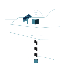
TONe Integrated Cloud Observatory (ICO)

The coupling between clouds and aerosols and their role in the radiative balance is an important factor in the warming of Antarctica. Albedo is the ratio of reflected to incoming solar radiation, and both clouds and aerosols affect this balance. The radiative effects of clouds and aerosols are two of the largest uncertainties in global climate models.
By establishing a completely new integrated cloud observatory at Troll, NP, together with international partners, will contribute to a better understanding of these processes. The instrumentation consists of a number of passive and active remote sensing instruments to measure temperature and humidity profiles and cloud and aerosol properties, and includes instrumentation for in-situ validation of the remote sensing instruments and a radiosonde system for daily balloon releases. This will be one of the few stations with such a measurement program in Antarctica.
TONe-ICO (blog)
TONe Seabird Monitoring Observatory (SMO)
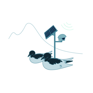 The two largest seabird colonies in Queen Maud Land are at Svarthamaren and Jutulsessen. Potentially more than 50% of the world’s population of Antarctic Petrels breed in the area. The main food source of the Antarctic Petrel is krill that it obtains from the Southern Ocean. The Antarctic Petrels thus function as so-called bio-indicators for the marine environment, so that by monitoring the petrel colony one can take the pulse of the marine environment in the Southern Ocean.
NP has monitored and researched seabirds in Svarthamaren irregularly since the 1980s. Through TONe, NP is further developing the monitoring by establishing automatic monitoring systems in two different colonies in the area.
Projects
CLIM2Ant
From Climatic Drivers to Antarctic Ice Sheet Response: Improving Accuracy in Sea Level Rise Projections
Sea level rise is one of the biggest consequences of climate change, and the melting of the Antarctic Ice Sheet (AIS) is a key factor with high uncertainty. The research project CLIM2Ant uses numerical models to better understand how climate and ocean currents affect the ice in Antarctica.
The Norwegian Polar Institute’s role in the project is to develop a regional sea-ice model. The model will be used to investigate how changes in the atmosphere and ocean affect the mass balance of the ice sheet in Dronning Maud Land, and thereby contribute to more precise projections of future sea level rise.
NARE Geology
NARE Geology
NARE Geology is a survey and research programme in Dronning Maud Land.
Most of the Antarctic is covered by ice, but where the mountains project up out of the ice, they are completely devoid of vegetation, giving geologists a unique opportunity to study the origins of the bedrock and the various geological process which have impacted on the Earth’s crust. Through field expeditions, the Norwegian Polar Institute collects geological map data, rock samples and field observations. Key scientific questions for NARE Geology are linked to metamorphic, structural, geochronological and tectonic studies of the mountain chain.
OCEAN:ICE
![]() Ocean-Cryosphere Exchanges in ANtarctica: Impacts on Climate and the Earth System (OCEAN:ICE)
Ocean-Cryosphere Exchanges in ANtarctica: Impacts on Climate and the Earth System (OCEAN:ICE)
OCEAN:ICE will assess the impacts of key Antarctic Ice Sheet and Southern Ocean processes on Planet Earth, via their influence on sea level rise, deep water formation, ocean circulation and climate. An innovative and ambitious combination of observations and numerical models, including coupled ice sheet-climate model development, will be used to improve predictions of how changes in the Antarctic and Greenland ice sheets impact global climate. It will make new circumpolar and Atlantic observations in observational gaps. It will assimilate these and existing data into improved ice sheet boundary conditions and forcing, producing new estimates of ice sheet melt and impacts on ocean circulation, including the Atlantic Meridional Overturning circulation. It will develop, calibrate and assess models used to predict the future evolution of the giant ice sheets. It will reduce the deep uncertainty in the impact of their melt on societally relevant environmental changes on decadal to multi-centennial time scales. It will assess the potential for passing ice sheet ‘tipping points’ and their consequences for ocean circulation and climate.
OCEAN:ICE er et nytt Horizon Europe-prosjekt, finansiert av EU-kommisjonen og UKRI. Prosjektet starter 1. november 2022 og vil pågå i 4 år frem til 31. oktober 2026.
CRiceS
![]()
Climate Relevant interactions and feedbacks: the key role of sea ice and Snow in the polar and global climate system
The CRiceS project focuses on improving model predictions of the role of polar processes in the climate system that consists of the oceans, ice and snow cover, and the atmosphere.
The CRiceS project brings together 20 international research teams, from Europe, Canada, South Africa, and India, at the forefront of polar and global climate research. The CRiceS research project aims to enhance the modelling of the impacts that these regions have for the global climate.
Read more: https://www.crices-h2020.eu/
iC3
Centre for ice, Cryosphere, Carbon and Climate (iC3)
Bringing together world-leading experts, the new Centre of Excellence, Centre for ice, Cryosphere, Carbon and Climate (iC3) will fill a vital knowledge gap in polar science by quantifying impacts of ice sheet change on Earth’s carbon cycle and sensitive ocean ecosystems.
Beyond Epica-Oldest Ice (BE-OI)
The ultimate goal of this project is to contribute data for a future deep ice core borehole in order to find 1.5-million year old ice from East Antarctica
The first phase of the project is being funded through the EU Horizon 2020 Coordination and Support Action call (2016 – 2019), which involves a consortium of 14 European institutions, including the Norwegian Polar Institute.
Dome C and Dome F are the two candidates defined in the first phase. The Beyond EPICA project comprises several phases involving drilling and analysis, which will continue over the next ten years.
Dome Fuji
This project investigates the deepest Antarctic ice sheet (Dome Fuji), the oldest atmospheric gas archive in the world, primarily by analyzing ice radar data. This region likely has ice that is about a million years old.
I-CRYME
Impact of CRYosphere Melting on Southern Ocean Ecosystems and biogeochemical cycles (I-CRYME)
Global warming is transforming Antarctica; melting the cryosphere (the ice caps, the glaciers and the sea ice); affecting the Southern Ocean physical dynamics and elemental cycles; and impacting the marine ecosystems and their capacity to absorb the atmospheric CO2 emitted by men.
The Southern Ocean is both home to rich ecosystems and a place where atmospheric CO2 is efficiently absorbed by the Ocean. A large part of this atmospheric CO2 is absorbed by phytoplankton and sea-ice algae which are limited by the availability of iron, a bio-essential element. Iron and other nutrients are highly concentrated within the cryosphere. The release of these elements and changes in the ocean dynamics linked to the melting cryosphere will have large consequences on marine ecosystems, their biodiversity and productivity. These consequences are not yet understood and research to improve our understanding is critical to predicting future changes.
This project aims to understand and quantify the impact of the melting cryosphere on the marine ecosystem of the Kong Håkon VII Sea, in the Southern Ocean. Towards this goal, I-CRYME combines field, laboratory and modelling activities that will generate novel datasets. The project utilizes the Research Vessel Kronprins Haakon, the Supply Vessel Silver Arctica that is commissioned annually by NPI to carry out research in the Southern Ocean; innovative technologies such as the TRIAXUS towed vehicle and long-term monitoring by deep-sea moorings in the area. The research activities will allow us to quantify the physical and biogeochemical properties during a time of rapid environmental change and to measure the response of the microbial community to the biogeochemical enrichment caused by the melting cryosphere. The project outcomes will shift our understanding of key processes in the Southern Ocean and improve our predictions of the future of its physical dynamics, its ecosystems and elemental cycles.
WOBEC
![]()
Weddell Sea Observatory of Biodiversity and Ecosystem Change (WOBEC)
With the Biodiversa+ project Weddell Sea Observatory of Biodiversity and Ecosystem Change (WOBEC), we aim to create the DNA of a distributed long-term ecosystem observatory in the Eastern Weddell Sea / King Haakon VII Sea in the Southern Ocean. The Weddell Sea is crucial for climate regulation and food provision and home to many protected species only occuring in waters around Antarctica. The EU and the Convention for the Conservation of Antarctic Marine Living Resources (CCAMLR) are working to establish a Weddell Sea Marine Protected Area (WSMPA).
Recent evidence shows significant ocean warming and sea-ice loss all around Antarctica, affecting biodiversity and ecosystem services. Realizing that no systematic ecosystem monitoring exists in the Eastern Weddell Sea, scientists of 11 institutes from 8 countries join forces together with stakeholders from economy, conservation and society to design and apply a monitoring framework supporting global biodiversity goals, establishing a baseline for measuring changes, and strengthening the WSMPA process.
Gerlache Strait
Spatiotemporal overlap of krill fishing with cetaceans and other krill predatorsThis project will address the key knowledge gap of krill fishery-predator interactions in a region where catch levels are proposed to increase substantially, and data collection has been acknowledged to be limited. Using passive acoustic monitoring (PAM) devices coupled with observers onboard krill fishing vessels, this project will elucidate the temporal trends in presence and abundance of cetaceans and other krill predators throughout the year, but especially though the late autumn and winter in the Gerlache Strait coinciding with the period that the fishery tends to move into the region. This project will also develop synergies with the krill fishery and the tourist industry to create a means by which management-useful levels of data can be collected throughout the foreseeable future in a cost-effective and predictable manner.
The project is funded by Antarctic Wildlife Research Fund (AWR) – project no 23/2023. The project started 1st October 2023 and will continue until 31st July 2026.
The Ny-Ålesund Programme
Through the research and environmental monitoring activities that have been the foundation of the Norwegian presence in Ny-Ålesund since the late 1960s, Ny-Ålesund Research Station today stands as a unique high-Arctic location that contributes many of the most important biological, atmospheric and physical data time series that are part of the global knowledge commons.
The extensive practical and logistical support offered in Ny-Ålesund makes it possible to conduct research and environmental monitoring at a high professional level, with a strong focus on safety in the field, and in a cost-effective manner.
The Ny-Ålesund Programme is responsible for ensuring that the Norwegian Polar Institute properly exercises the hosting role, and implements the research strategy for the Ny-Ålesund Research Station.
Contact
Programme leader: Geir Gotaas
Outreach contact: Stig Mathisen
Ny-Ålesund Research Station. Photo: Trine Lise Sviggum Helgerud / Norwegian Polar Institute
The Arctic Ocean Programme
The Arctic is changing rapidly, with rising temperatures in the ocean and atmosphere and decreasing ice cover. Ecosystems and human activity in the area are also changing. Better knowledge of the ongoing changes and the mechanisms that control these is necessary to be able to predict the changes that nature and society will face when most of the Arctic Ocean soon will be ice-free for parts of the year.
Through monitoring and research, we produce data and knowledge to advise management on the status, variability and development trends in climate, natural environments and ecosystems, and on the drivers of these changes. The knowledge provides the basis for advice to authorities for use in national ocean management and internationally (working groups in the Arctic Council, IPCC, etc.), and is disseminated in scientific forums and to the general public.
The geographically most important areas for the Arctic Ocean Programme are the northern ocean areas where Norway has a special responsibility for management; the northern Barents Sea, the Fram Strait and the Nansen Basin, and the interaction between the ocean and the coastal areas of Svalbard.
Contact
Programme leader: Arild Sundfjord
Outreach contact: Stig Mathisen
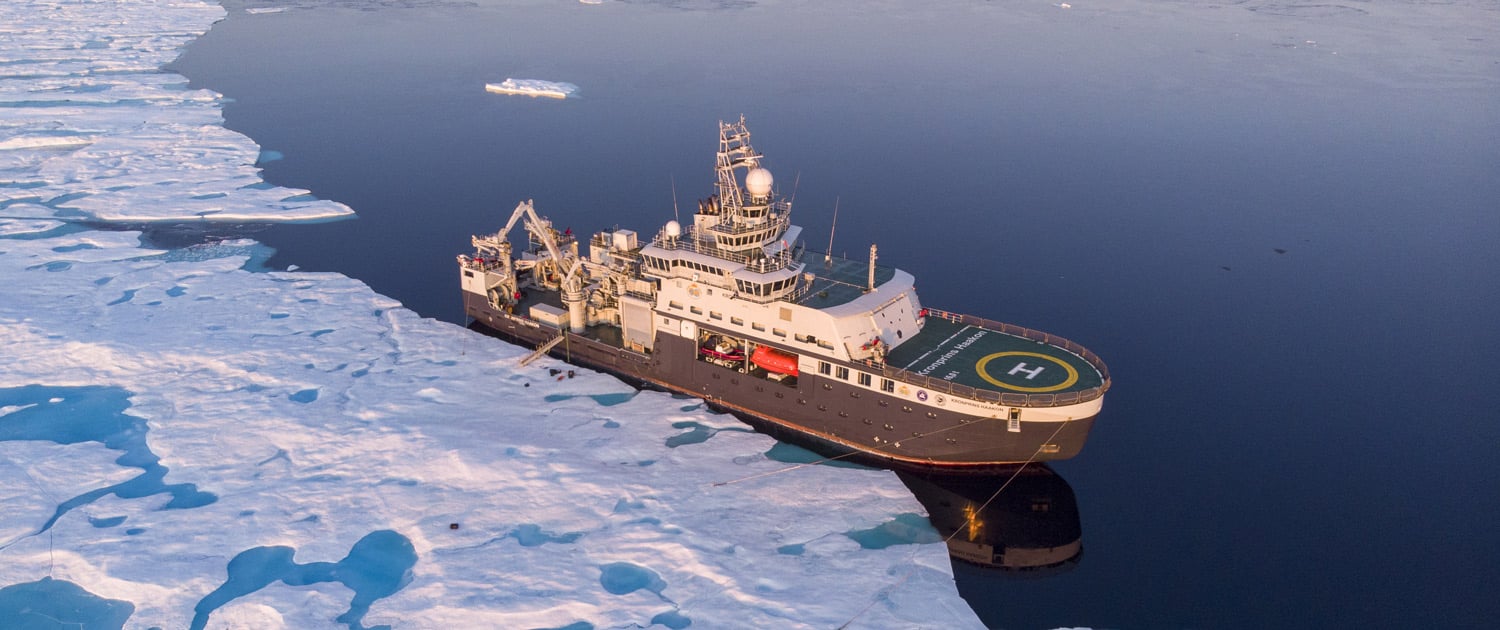
The research vessel Kronprins Haakon in the Arctic Ocean. Photo: Lawrence Hislop / Norwegian Polar Institute
Monitoring
Fram Strait
This long-term project monitors the ocean currents and sea ice leaving the Arctic Ocean through Fram Strait.
The project maintains a mooring array which provides a continuous, high-resolution time series of temperature, salinity, velocity and sea ice thickness measurements in the Arctic outflow. Additional measurements, as well as water samples and sea ice cores are collected along an annually repeated section every September when the mooring array is serviced.
Long-term variability and trends in the Atlantic Water inflow region
Long-term variability and trends in the Atlantic Water inflow region (A-TWAIN)
Warm water that flows northward from the Atlantic and into the Arctic Ocean plays a crucial role for regional environmental conditions. The project collects data on the variability and changes in the Atlantic Water that enters the Arctic Ocean north of Svalbard, through moorings and bi-annual ship-borne surveys.
Monitoring climate and environmental conditions in the Arctic Ocean
Marine mammals and marine soundscape
More information will come.
Projects
Arctic Ocean 2050
![]()
The Arctic Ocean is fundamentally changing as a result of ongoing climate change. Within the next 25 years, summer ice in the Arctic Ocean will be a thing of the past. Together with this plain to see change, comes other changes that may be of critical importance, but are less visible. A new Arctic Ocean requires new knowledge and insight into changes, how they interact and links to areas further south.
Arctic Ocean 2050 brings together the full width of the Norwegian research community in a joint, interdisciplinary research program. Arctic Ocean 2050 will provide fundamental and applicable knowledge and skills that are urgently needed. This ten-year program will facilitate the development and implementation of updated management principles in the new, blue Arctic Ocean.
SUDARCO
Sustainable Development of the Arctic Ocean (SUDARCO)
The marine ecosystem in the Arctic Ocean is heavily understudied, but existing research suggests that it is challenged by the large and rapid changes in the environment. Expectations of increased human activity create a need for updated management instruments and guidelines. This requires an integrated management approach, and then we need a reliable understanding of the areas that have recently become, or will soon become, available.
Our overall goals are therefore to identify and collect the core observations needed to understand the newly accessible marine environment and ecosystem, and to synthesize and disseminate the knowledge needed to ensure the safe and sustainable use of these areas.
EPOC
![]()
Explaining and predicting the ocean conveyor (EPOC)
Generating a new concept of the Atlantic meridional overturning circulation (AMOC), its function in the Earth system and how it impacts weather and climate.
EPOC will generate a new conceptual framework for the Atlantic meridional overturning circulation, to understand how it functions in the Earth system, and how it impacts weather and climate. The AMOC is a key component of the climate system, responsible for ocean heat and freshwater transport, associated with the ventilation of anthropogenic carbon, and anticipated to experience or drive climate tipping points. However, the link between ocean transport, ventilation and tipping points relies on the common conceptual view of the AMOC as a ‘great ocean conveyor’ which was developed to explain very long timescale (glacial-interglacial) fluctuations in climate. The conveyor belt schematic conflates millennial timescales with human timescales (days to 100 years), leading to misconceptions by the observing and modelling communities, and misplaced expectations about the AMOC’s role in climate.
EvoCal
Arctic Marine Evolution: using local adaptation to infer future evolutionary responses of Calanus copepods to a changing environment (EvoCal)
The EvoCal project investigates whether two key copepod species, Calanus finmarchicus and Calanus glacialis, can adapt to future climate change through acclimatization or genetic adaptation. These species are vital to Arctic and North Atlantic food webs.
We study populations along the Norwegian coast—from temperate waters to the High Arctic—by:
- Measuring environmental variability using advanced sensors,
- Mapping genetic population structure with new genomic tools, and
- Testing physiological tolerance to temperature, pH, and salinity.
By combining field data, lab experiments, and evolutionary theory, EvoCal aims to improve predictions of how these species will respond to a changing ocean.
Arctic PASSION
![]()
Pan-Arctic observing System of Systems: Implementing Observations for societal Needs
The project will develop an integrated, comprehensive, pan-Arctic observation system, through international cooperation.
Under the leadership of the German Alfred Wegener Institutt (AWI) 35 partners in 17 countries will work for further development, better coordination, and contribute to wider use of observation data from the comprehensive Arctic observation system. User groups are the local population in the Arctic, research environments, business and authorities.
The Norwegian Polar Institute will deploy instrument rigs for long time series in the Arctic Ocean, and deploy buoys for sea ice measurements. The ice-going research vessel Crown Prince Haakon will be an important platform for this work.
BREATHE
Bottom-sea ice Respiration and nutrient Exchanges Assessed for THE Arctic (BREATHE)
Polar amplification of global warming has transformed the Arctic marine system and its sea ice cover. Reductions of ice thickness, distribution and extent have substantially impacted sea ice habitats and the microorganisms living within them. Algae are important members of sea ice microbial communities; their spring bloom kick-starts annual primary production that contributes to trophic function and carbon cycling in the marine ecosystem. However, current estimates and modeled projections of sea ice algal productivity are compromised by incomplete characterization of two key processes, i) turbulence-driven nutrient supply and, ii) algal respiratory costs of living in a harsh ice environment. Furthermore, inherent methodological constraints of studying sea ice has meant an underrepresentation of in situ measurements that are unbiased by experimental artifacts and thus invaluable for our understanding sea ice habitats. The BREATHE project will combine in situ, experimental and model-based approaches to address knowledge gaps on turbulent nutrient supply and ice algal respiration, with results that improve the accuracy of current and projected ice algal production estimates. Towards this purpose the project will develop and apply state-of-the-art O2 methods for the study of sea ice biogeochemistry. It will complete fieldwork in contrasting regions of the Arctic to characterize productivity and turbulence-driven nutrient regimes of different sea ice habitats, which will inform innovative experiments that provide the first empirical description of ice algal respiration and its variability. Integrated modeling will provide the unique opportunity to implement and directly test parameterizations of respiratory and nutrient processes, before they are applied for prediction. Project outcomes will represent a paradigm shift in our understanding of sea ice primary production, with implications for the management of ecosystem services it supports like, greenhouse gas regulation.
Seabird tracking

The SEATRACK programme aims to map the non-breeding distribution of seabirds breeding throughout the North Atlantic and understand how changes in environmental conditions and other threats affect their demography and population trajectories.
The programme was initiated in 2014 and is currently in its third phase. It is a large-scale
international collaboration of 69 partners from 52 institutions based in 14 countries.
HiAOOS

HiAOOS aims to advance the uptake of new ocean observing capabilities and capacity in the high Arctic to strengthen European and national infrastructures in their effort to support new and ambitions research within climate, environment and geohazards. HiAOOS will develop, implement, and validate several ocean observing technologies to improve data collection in the ice-covered Arctic Ocean. The research project started in 2023, is funded by the EU and is led by the Nansen Centre (NERSC) in Bergen.
Former large projects
Nansen Legacy
![]() The Nansen Legacy is a novel and holistic Arctic research project that provides the integrated scien-tific knowledge base required for the sustainable management through the 21st century of the environment and marine resources of the Barents Sea and adjacent Arctic Basin.
The Nansen Legacy is a novel and holistic Arctic research project that provides the integrated scien-tific knowledge base required for the sustainable management through the 21st century of the environment and marine resources of the Barents Sea and adjacent Arctic Basin.
An ice-free Arctic is gradually emerging. Wintertime sea ice retreat is to date most pronounced in the Barents Sea, the Atlantic gateway to the Arctic. The knowledge basis for sustainable management of this changing environment and the associated resources is an urgent scientific challenge.
GoNorth
![]()
GoNorth is a consortium made up of research groups from Norwegian universities and institutions. The purpose is to explore the Arctic Ocean from the underground, the seabed, the water and even the newspaper through joint multidisciplinary research.
The Svalbard Programme
Svalbard is the place on Earth where the temperature increase is currently the fastest. The physical changes that result from this affect the ecosystem, infrastructure and human activities in this region. This in turn changes the risk levels for endemic flora and fauna and their habitats on land and at sea.
Through mapping, monitoring, research and international cooperation, the Svalbard Programme produces data and knowledge as a basis for advice to management on the geology, climate, ecosystems and environmental development in Svalbard. The programme also contributes input to larger Arctic and global conservation work processes (such as the Arctic Council, OSPAR, IUCN and others).
Activities take place across the archipelago, with key locations around Longyearbyen, Ny-Ålesund and research locations at small stations on islands in the north and south-east.
Contact
Programme leader: Kit Kovacs
Outreach contact: Elin Vinje Jenssen

Glacier with melt ponds and crevasses. Photo: Samuel Martínez Llobet / Norwegian Polar Institute
Monitoring
Mass balance glaciers
Kongsfjorden
The mass balance of certain glaciers is measured in the field by obtaining data in the spring and autumn. This data is used to calculate the winter balance (accumulation) and summer balance (melting), which are then added together to produce the net balance, the annual state of health of the glacier between two consecutive autumn measurements. The mass balance primarily depends on precipitation in the winter and temperature in the summer, but calving and marine melting are also important for some glaciers which terminate in the sea.
Mass balance is measured in the field for only a few glaciers in Svalbard, which are located almost exclusively along the west coast of Spitsbergen. The Norwegian Polar Institute is currently measuring the mass balance of four glaciers in the Kongsfjord area: Austre Brøggerbreen (since 1967), Midtre Lovénbreen (since 1968), Kongsvegen (since 1987) and Kronebreen/Holtedahlfonna (since 2003).
Austfonna
The Norwegian Polar Institute and the University of Oslo are cooperating concerning the taking of mass balance measurements on Etonbreen, an arm of Austfonna. Austfonna is the largest ice cap in Svalbard and has been monitored using a weather station and annual mass balance measurements since 2004. Extensive, gently sloping formations and relatively easy access make Austfonna ideal for the calibration and validation of satellite data and climate models with relevance to the larger ice masses of Greenland and Antarctica. As part of the CryoVEX programme of the European Space Agency (ESA), regular programmes have been carried out using coordinated aerial and ground-based readings for comparison with satellite data. The mass balances from Etonbreen on Austfonna form part of the climate monitoring being carried out under MOSJ with annual updates.
Read more about measuring the mass balance of glaciers in Svalbard (MOSJ)
Atmospheric radiation (Troll og Zeppelin)
Atmospheric radiation is continuously measured at the Zeppelin Observatory in Ny-Ålesund and at the Troll Research Station in Dronning Maud Land, Antarctica. Both sites have instruments mounted on a platform which moves with the sun, enabling us to measure the light that comes directly from the sun separately from what is dispersed by the atmosphere and originates from the rest of the sky. One instrument measures all incoming sunlight from all directions, while another measures infrared light radiated by the atmosphere. Using these measurements, we are able to monitor an important part of the climate system – the energy that is available to heat the surface of the Earth. We can also better understand the importance of processes in the atmosphere that affect sunlight and the radiation of infrared light (e.g. clouds).
Miljøprøvebanken
More information will come.
Sjøis i kystområder
More information will come.
Pelagisk sesongovervåking i Kongsfjorden
More information will come.
MOSJ

COAT
![]() Climate-Ecological Observatory for Arctic Tundra (COAT)
Climate-Ecological Observatory for Arctic Tundra (COAT)
COAT is an ecosystem-based observation system established to uncover and document the effects of climate change in low-Arctic tundra areas in Finnmark and in high-Arctic areas in Svalbard.
In Svalbard, warming is occurring four times faster than elsewhere on the planet, and the first and most extensive natural changes are being felt here. Through five biological modules and a climate network, climate-sensitive species and functional groups are monitored via annual registrations of the entire food chain, as well as continuous real-time monitoring of weather and climate in both coastal and inland areas. Field registrations and automated technology, such as listening boxes and game cameras, drones, satellite data and transmitters on animals, contribute to developing cause-and-effect models that predict climate effects on the tundra food web.
Through COAT-Svalbard’s work, a solid scientific basis is created that is used for analyses and predictions. This knowledge makes it possible to provide management advice that helps us meet the climate crisis and its consequences for nature in the Arctic. Monitoring has already documented that Svalbard is rapidly moving out of previous climate zones. At the same time, the populations of barnacle goose, short-billed goose, Svalbard ptarmigan and Svalbard reindeer have increased, while the arctic fox population is stable. Changes in vegetation have also been recorded as a result of ice cover on the tundra in winter and grazing pressure from short-billed geese. The results from COAT-Svalbard provide Norway and the international community with valuable data on the consequences of climate change for the tundra ecosystem in Svalbard.
COAT-Svalbard is led by the Norwegian Polar Institute, but collaborates closely with UiT (University of Tromsø), MET (Meteorological Institute), NINA (Norwegian Institute for Nature Research) and UNIS (University Centre in Svalbard). The program builds on and expands the terrestrial monitoring in MOSJ (Environmental Monitoring for Svalbard and Jan Mayen) and is a large part of the land module in SIOS (Svalbard Integrated Arctic Earth Observing System).
SEAPOP
![]() SEAPOP (SEAbird POPulations) is a seabird monitoring programme which began back in 2005. The programme combines the long-term demographic monitoring of various populations with diet and tracking studies in order to determine the mechanisms which govern the population dynamics and prevalence of the seabirds.
SEAPOP (SEAbird POPulations) is a seabird monitoring programme which began back in 2005. The programme combines the long-term demographic monitoring of various populations with diet and tracking studies in order to determine the mechanisms which govern the population dynamics and prevalence of the seabirds.
In Svalbard and Jan Mayen, seven species are being monitored: common guillemot, thick-billed guillemot, kittiwake, glaucous gull, ivory gull, great skua and little auk. Fulmar, northern gannet and puffins are also being monitored.
Projects
Kongsvegen geophysical observatory
Observations of various atmospheric and glaciological aspects of the equilibrium line altitude at Kongsvegen will contribute to mass balance modelling and process understanding, as well as improved monitoring of the extensive area of Spitsbergen that is covered by glaciers.
TIGRIF
TIdewater Glacier Retreat Impact on Fjord circulation and ecosystems
The main objective is to assess what happens to fjord circulation and ecosystems when tidewater glaciers retreat to the point where they no longer terminate in water but on dry land. This will be done using an ocean circulation model and scenarios of glacier retreat. Modelling will be performed on the Kongsfjord system in north-western Svalbard. This project has been financed by the Research Council of Norway (program HAVKYST).
FACE-IT
![]()
FACE-IT aims to enable adaptive co-management of social-ecological fjord systems in the Arctic in the face of rapid cryosphere and biodiversity changes.
Glacier fronts and sea ice systems are hotspots of biodiversity. Their retreat will pose threats to Arctic coastal ecosystem function and eventually local livelihoods. The Arctic is a harbinger of the consequences of multiple global and regional environmental change on ecosystems and livelihoods: The overarching objective of FACE-IT is to enable adaptive co-management of social-ecological fjord systems in the Arctic in the face of rapid cryosphere and biodiversity changes.
Objectives
- Identify and quantify key drivers of biodiversity changes and their past and future trends.
- Identify cascading effects of a changing biodiversity associated with ongoing and projected changes in Arctic coastal food webs.
- Assess the interdependencies between environmental changes and Arctic coastal livelihoods.
- Support adaptive co-management at the local and national levels.
ARK
Arctic marine mammals in a time of climate change: a Kongsfjorden Case Study (ARK)
Declines in sea ice (volume, extent, seasonal coverage) and melting and retraction of tidewater glaciers in the Arctic are particularly visible signs of change that is occurring due to global warming. Degradation of both of these physical features of Arctic marine systems are happening more rapidly in the northern Barents Sea than elsewhere in the circumpolar Arctic making the Norwegian High Arctic is a bellwether of climate change for the entire region. The shrinking of sympagic habitats and concomitant Atlantification of Arctic food webs, will undoubtedly have profound implications for marine ecosystems in the High North; the expected implications for endemic Arctic marine mammal species have been described as “transformative”. The ARK research programme will use a variety of “captured” and extended data time series (abundance, ecology, diet, contaminant levels, disease/health, trophic interactions etc) to quantitatively test four principle hypotheses regarding how marine mammals (especially resident endemic Arctic seals but also other species) are being impacted by global warming: 1) H1 – Declining ice habitats will induce abundance declines in ice-dependent species and result in redistributions, and over longer time frames extirpations; 2) H1 – Arctic endemic species will face increasing competition from temperate species that are expanding their ranges; 3) H1 – the health of Arctic endemic species will be negatively impacted by increasing exposure to diseases and increased impacts of contaminants and 4) H1 – Atlantification of food webs will affect Arctic marine mammals negatively, creating risks of cascading impacts through Arctic ecosystems. ARK will take a case-study approach, using Kongsfjorden on the west coast of the Svalbard Archipelago to explore ecosystems change, employing state-of-the-art physical-biogeochemical food web models and complex adaptive
CLEAN
Cumulative impact of multiple stressors in High North ecosystems (CLEAN)
The CLEAN project deals with the combined effect and risk associated with several stress factors in the ecosystems in the northern regions.
The project investigates how climate change, short- and long-range pollutants, species invasions and human activities, such as harvesting and aquaculture, jointly affect ecosystems, including goods and services in them. In addition, CLEAN evaluates the management challenges and opportunities to reduce the overall impact.
Metallica
More information will come.